D-Lib Magazine
March/April 2015
Volume 21, Number 3/4
Table of Contents
Reconstructing the Past Through Utah Sanborn Fire Insurance Maps
A Geospatial Approach to Library Resources
Justin B. Sorensen
J. Willard Marriott Library, University of Utah
justin.sorensen@utah.edu
DOI: 10.1045/march2015-sorensen
Printer-friendly Version
Abstract
Cartographic maps have the ability to convey information and ideas in ways text cannot. The Utah Sanborn Fire Insurance Maps are one such resource, depicting detailed information on buildings, layouts, compositions and boundaries of cities and towns. As time has progressed, the interest in these resources has continued to grow, opening the door for the creation of an updated method for viewing and examining this valuable collection. Through the incorporation of GIS and geospatial technology, the printed and scanned materials have been converted into georeferenced raster datasets, allowing viewers the ability to geospatially interact with the information and apply the information to their research in new and exciting ways. This article describes the Digital Scholarship Lab's endeavor to convert these valuable resources into research driven geospatial datasets, providing a new format for how the library information is presented as well as a new method for interacting and examining the information in detail.
Introduction
Sanborn Fire Insurance Maps are a highly requested resource in libraries. Each collection of hand-made maps contains detailed surveyor information on commercial, industrial and residential sections of cities and towns ranging from the mid 1800s to the mid 1950s (Figure 1). While the J. Willard Marriott Library has scanned and created digital versions of the original printed maps, the Digital Scholarship Lab established a goal to further develop, enhance and utilize the information contained within these maps. As a result, an innovative project was created that not only offers these resources openly to students, staff, faculty and visitors of the University of Utah, but also creates a method for displaying and examining each map within physical space through the incorporation of geospatial software and 3-dimensional technology.
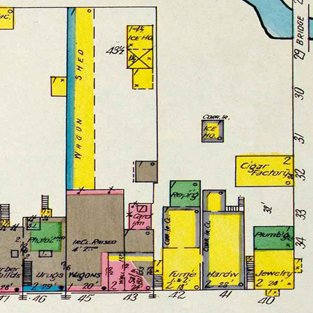
Figure 1: Portion of original scanned 1908 Mount Pleasant Sanborn Map (close-up detail).
[ View larger version of Figure 1. ]
Project Development and Process
Beginning in 1867, Sanborn Fire Insurance Maps (founded by Daniel Alfred Sanborn) were created for the purpose of assessing fire insurance liability within urbanized areas of the United States, depicting detailed information on cities and towns consisting of: building compositions and structural information, layouts, business and street information, property boundaries and much more ("Sanborn Maps", 2014). Author Kim Keister describes this collection well, stating "the Sanborn maps survive as a guide to American urbanization that is unrivaled by other cartography and, for that matter, by few documentary resources of any kind" ("Sanborn Maps", 2014). As time has progressed, each published volume and its descendent updated versions have become highly requested resources in fields such as historical research, planning, preservation and the study of urban geography ("Sanborn Maps", 2014). While many of these collections are available at academic institutions, most are archived in their original printed format for preservation, thus limiting the ability to openly obtain information contained within each detailed map.
In 2000, the J. Willard Marriott Library's Digital Technologies staff began the sizable task of scanning each Utah Sanborn Fire Insurance Map contained within the Special Collections department (Arlitsch, 2002). This effort produced high-resolution scanned tiffs of the entire collection (numbering over 1,700 maps in total) made viewable through a webpage specifically designed to present the entire scanned map collection (Figure 2). As time progressed and the interest in this resource continued to grow, an updated method for viewing this valuable collection while interacting and examining the information closely was in order. What better way to accomplish this goal than to incorporate GIS and geospatial technology, thereby converting the printed and scanned materials into geospatial raster data while offering a new method and format for the J. Willard Marriott Library to offer these resources and a convenient way for individuals to access and examine the detailed information remotely.
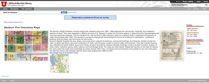
Figure 2: Screenshot of scanned Utah Sanborn Fire Insurance Map portal located in the J. Willard Marriott Library's Digital Library.
[ View larger version of Figure 2. ]
GIS stands for Geographic Information System, which is an assemblage of computer hardware, software and data designed to examine and present geospatial data by combining spatial mapping and analysis with database technology. With software such as this, it becomes possible to turn ordinary printed data and imagery into geospatial data, identifying geographic features, locations or boundaries on the Earth. For the Utah Sanborn Fire Insurance Maps, this process would involve converting each scanned map into a georeferenced overlay, a process by which a 2-dimensional printed map or photographs existence is defined within physical space by giving the image latitude and longitude coordinates dependent upon a particular map projection system, resulting in the digital map's alignment to its appropriate geographic location within a virtual environment.
The original scanned tiffs created by the J. Willard Marriott Library's Digital Technologies staff were first converted from large file sizes (approximately 148 MB per map) to smaller web-sized jpeg images (2 -3 MB per map) by Digital Scholarship Lab staff using Photoshop to allow for easy remote access while preserving image quality. The map collection was georeferenced using ArcGIS software, aligning each map to its appropriate geospatial location through established georeferencing protocols to maintain consistently projected digital overlays for all of the historic maps. These protocols include the use of reference layers composed of satellite imagery, street centerlines and parcel data as well as the utilization of a NAD83 projected coordinate system (North American Datum, 2014). The georeferenced maps were then converted to KMZ files ("Keyhole Markup Language", 2014) using Global Mapper software, allowing each map to be viewed in detail using free and openly available Google Earth software (Figure 3). While great care has been taken to maintain georeferencing accuracy, it is important to note that many map features have changed or vanished over time, resulting in the georeferencing of each historic map as close to its appropriate geographic position as possible.
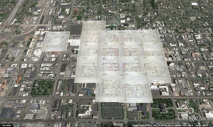
Figure 3: Digital aerial view of the georeferenced 1884 Salt Lake City Sanborn map collection overlaid within Google Earth on present-day satellite imagery for comparison.
[ View larger version of Figure 3. ]
With the completion of the georeferencing process, all georeferenced map files were delivered to staff members of USpace (the University of Utah's Institutional Repository), who uploaded each georeferenced map individually as compound objects using CONTENTdm software while entering geospatial metadata for each of the georeferenced maps, opening access to the newly created materials via URL links accessible within the J. Willard Marriott Library catalog.
As the geospatial components were becoming openly available to students, staff, faculty and visitors of the University of Utah, a method for quickly accessing the information and datasets contained within the new collection was in order. This process would lead to a number of brainstorming sessions on how to best present the information and ideas for different display components visitors would utilize prior to download. As a result, a library study guide hosted on the J. Willard Marriott Library's website was created (Figure 4), conveniently navigating visitors throughout the entire map collection. Each city tab within the study guide represents one of several geographic locations depicted in the Utah Sanborn Fire Insurance Map collection, displaying each geographic set by the year in which it was created, ranging from the mid 1800s to the mid 1950s. Links to each year's collection are available for the original scanned tiffs as well as the newly georeferenced materials available for download while embedded Google Earth gadgets offer visitors the opportunity to interact with each map collection within a 3-dimensional environment prior to download.
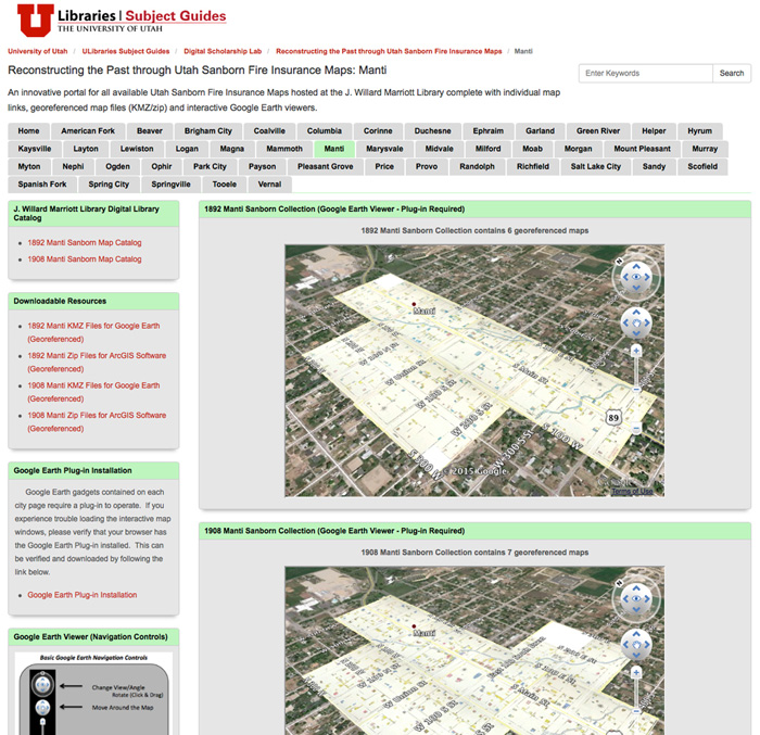
Figure 4: Screenshot of the project study guide hosted on the J. Willard Marriott Library's website including links to original scans, georeferenced materials and embedded interactive Google Earth gadgets displaying each collection by location.
[ View larger version of Figure 4. ]
Benefits of this Project
Adding a geospatial component to library materials allows the information to be displayed, expressed and presented in ways standard printed or scanned information cannot. By utilizing GIS and geospatial technology with the incorporation of geospatial datasets such as these, a new realm for library research is opened, allowing research institutions a new method for sharing information in a world more and more reliant on digital information. Ranging from the creation of historical reconstruction models (Figure 5), interactive 3-dimensional model overlays (Figure 6), planning analysis or the study of change over time, individuals from multiple disciplines are now able to utilize the georeferenced Utah Sanborn Fire Insurance Maps in new and exciting ways.
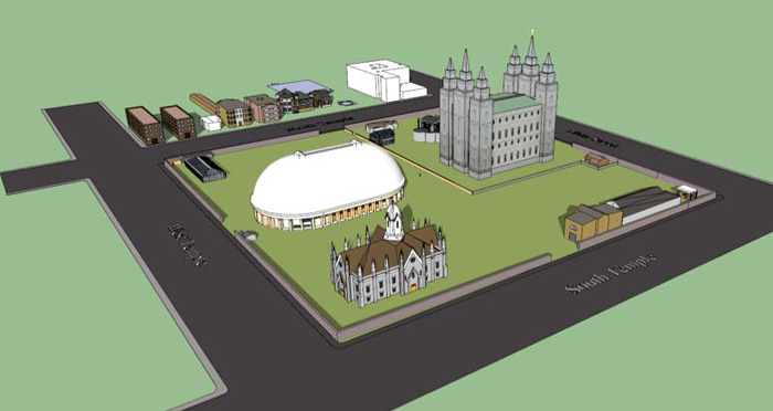
Figure 5: Detailed 3-dimensional model created by Caitlyn Tubbs (Digital Scholarship Lab) based on information contained in a georeferenced 1950 Salt Lake City Sanborn Fire Insurance Map.
[ View larger version of Figure 5. ]
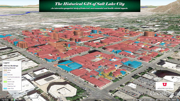
Figure 6: Interactive 3-dimensional model created by Justin Sorensen (Digital Scholarship Lab) based on information contained in a set of georeferenced 1950 Salt Lake City Sanborn Fire Insurance Maps.
[ View larger version of Figure 6. ]
Project Results
This project has resulted in the creation of an innovative portal for all Utah Sanborn Fire Insurance Maps hosted at the J. Willard Marriott Library complete with links to individual maps contained within our collection, georeferenced maps available for download in both KMZ (Google Earth) and zipped geo-raster jpeg (ArcGIS) formats for access by students, staff, faculty and visitors of the University of Utah, as well as interactive Google Earth gadgets embedded within each geographic page of the project study guide, "Reconstructing the Past Through Utah Sanborn Fire Insurance Maps", displaying each collection of georeferenced maps while overlaying them on a virtual 3-dimensional model of the Earth.1
Conclusion
This project demonstrates not only how printed, scanned and highly-requested library resources such as the Utah Sanborn Fire Insurance Maps can be converted into research driven geospatial datasets, but also one of the many ways in which GIS can be beneficial in sharing library collections while taking library research to a new level. Geospatial technology is an amazing resource available and within a world continually converting towards a digital realm, GIS will be one of the many tools libraries will have available to assist them in geospatially sharing their resources with others.
Acknowledgements
The author would like to acknowledge the work of fellow Digital Scholarship Lab staff member Caitlyn Tubbs (Geospatial Data & Visualization Intern) for her georeferencing assistance and USpace staff members Donald Williams (IR Coordinator) and Cindy Russell (IR Workflow Specialist) for their work uploading each of the map
files and applying metadata.
Notes
1 The gadgets contained on each city page of the study guide require a Google Earth plug-in to operate. If you experience trouble loading the interactive map windows, please verify that the plug-in is installed on your browser (recommend browser: Firefox).
References
[1] "Sanborn Maps." Wikipedia. Wikimedia Foundation.
[2] Arlitsch, Kenning. "Digitizing Sanborn Fire Insurance Maps for a Full Color, Publicly Accessible Collection." D-Lib Magazine, Vol. 8, No. 7/8, July 2002. http://doi.org/10.1045/july2002-arlitsch
[3] "North American Datum." Wikipedia. Wikimedia Foundation.
[4] "Keyhole Markup Language." Wikipedia. Wikimedia Foundation.
About the Author
 |
Justin Sorensen is the GIS Specialist for the J. Willard Marriott Library's Digital Scholarship Lab. A graduate of the University of Utah, Justin has a strong background in geography and geospatial technology and has been creating, developing and managing geospatial projects for the Digital Scholarship Lab since 2011.
|
|